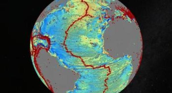
Researchers have created a highly detailed map of the Earth's seafloor, revealing previously unknown mountains, crevasses, and scars along the deepest unknown parts of the ocean.
Using satellite data, scientists have produced a map of the Earth’s seafloor that shows previously uncharted crevasses, mountains, and scars in some of the most remote regions of the ocean.
The research was culled from NASA’s Jason-1 satellite and the European Space Agency’s CryoSat-2 satellite, which used sophisticated radar to map underwater territory.
While 71% of the Earth is covered by water, over 90% of the seafloor hasn’t been charted. The disappearance of Malaysia Airlines MH370 recently highlighted how little scientists understand about global currents, crevasses, and depths.
The study was led by David Sandwell of the Scripps Institution, a geophysicist who studies plate shifts. According to Sandwell, “The pull of gravity reflects the topography and tectonics of the seafloor.” This accounts for the previously unknown underwater mountains, ridges, and deep scars.
The map shows a number of seafloor and sub-seafloor attractions including a mid-ocean ridge along the Gulf of Mexico and another major ridge just west of Angola. These ridges are caused by tectonic plate shifts where molten rocks hardened and cooled along the scars.
Dietmar Muller, another researcher from the University of Sydney, believes that the new map can help geologists understand Earth’s history. “Knowing where and when such ridges existed is essential for deciphering planet Earth’s geological past,” Muller said.
The map also has implications for military and industrial applications. Oil reserves could be hiding beneath undersea mountains, and full knowledge of the planet’s topography could aid future military efforts.
Muller also remarked that a full survey of the ocean using acoustic beams could provide additional data, but cost between $2 to $3 billion. The satellite version is a far cheaper option for mapping the ocean floor’s topography.
Neither satellite was originally launched to create a seafloor map. CryoSat-2 was meant to monitor ice thickness changes in ice sheets over the polar regions, while Jason-1 was supposed to map ocean topography based on shifting currents.
Leave a Reply