Working with a research team from the University of Maryland, Google lent its significant Google Earth data to help develop a map charting global forest loss over the past decade or so.
When Google Earth was introduced in 2005, the virtual globe program was little more than a toy that people could use to explore the world from the comfort of their own computer chairs. Today, however, the 3D geography software has developed a number of useful applications, from assessing the damage of nature disasters to teaching world geography in classrooms. As Google has continued to flesh out its maps and add 3D support for different parts of the globe, Google Earth has continued to become a more useful tool.
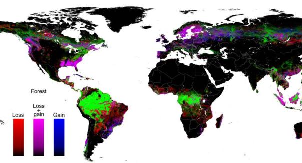
This week, Google added another notable application to Google Earth’s burgeoning resume. Working with a research team from the University of Maryland, Google lent its significant Google Earth data to help develop a map charting global forest loss over the past decade or so. Called the “Global Forest Change” project, the interactive mapping tool borrows Google Earth’s meticulous maps to offer detailed views of forestation change, both on a worldwide scale and on a close local level.
According to a report published by BBC News, the map reflects worldwide forest changes from 2000 through to 2012. The project looked at some 650,000 satellite images to determine where forest had been gained, lost, or mostly stayed the same during that time. And while a glance at the map may make deforestation seem like no big deal – after all, green (which shows “forest extent”) is a far more prevalent color on the map than red (which shows forest loss) – the BBC indicates that the situation is still dire. In the first 12 years of the new millennium, the world lost a combined forest totaling about 1.43 million square miles – the size of Mongolia.
So what was the cause of the destruction, and can it be reversed? The causes, of course, were varied, ranging from logging and clear-cutting to fires, natural disasters, and tree diseases. For instance, some of the most substantial forestation losses in the United States were seen out west, where wildfires have raged on numerous occasions over the past 13 years. Similarly, areas along the Gulf of Mexico or on the east coast showed both loss and gain of forest area, due likely to destruction from hurricanes and other natural disasters, as well as to later revitalization efforts.
Not everything looks bleak. Brazil has made a strong effort at protecting its forest areas, and the project also found that over 497,000 square miles of forest had been gained worldwide to offset the losses.
Leave a Reply